Regeneration of regional industrial territories. Intellectual business tour “Low-rise buildings. Regeneration of industrial areas. Experience of Belgium and Holland". Melbourne's high-rise center
The term “regeneration” can and probably should be considered in two aspects:
Firstly, as one of many dozens of terms starting with the prefix “re-...”, having multiple connotations of meaning a return to a past state, its restoration, the resumption of some activity, the birth of something again, etc. Many of these terms are used in cultural heritage conservation; Moreover, in different countries, preference is given to different terms, and the meanings actually put into the same terms can differ greatly.
Secondly, as a term that has received particularly significant application in the practice of preserving cultural heritage in our country, where it has been used since the 1980s. is increasingly actively and widely used to refer to this type of action in construction and urban planning, which is characterized by a careful attitude towards immovable heritage sites and the historical environment of settlements, and the desire to restore their city-forming role. Moreover, in 2002 the term was enshrined in the Federal Law “On Objects of Cultural Heritage...”, where “preservation and regeneration historical, urban planning or natural environment" is recognized as the only possible goal of construction activities in the territory of protective zones of cultural heritage sites (No. 73-FZ, Article 34, Part 2).
At the same time, one often has to deal with very different interpretations of the content of this normative establishment, which negatively affects the practice of actions of state bodies for the protection of cultural heritage and the objectivity of the conclusions of the state historical and cultural examination.
It should immediately be noted that between the use of the term “regeneration” in a broad sense - in urban planning activities for the careful, contextual reconstruction of quite significant territories, and in a narrow sense, relating to possible construction actions in protected zones of cultural heritage sites, usually having order of magnitude smaller than in the previous case, there is a big difference. Obviously, one should keep in mind two different interpretations of this term in relation to these tasks, although it is desirable, nevertheless, that these interpretations would somehow be mutually consistent and not be completely different directions.
In urban planning activities, the term “regeneration” began to be quite actively used in the USSR starting from the late 1970s. to characterize an integrated approach focused on the effective preservation and use of architectural and urban heritage and designate the work that implements such an approach.
At the same time, a terminological division of the country occurred. In Moscow, Leningrad, and most of the Russian Federation, urban planners working in the historical environment preferred to use the term “reconstruction”, despite its certain compromise by the heritage-destructive practice of “socialist urban reconstruction” and semantic ambiguity. Yet for most conservationists in the world, reconstruction means “rebuilding”, or even “building anew”, in some ways even corresponding to our modern “reconstruction”. To capture the specific, saving nature of reconstruction, it was sometimes additionally classified as “comprehensive”, “sparing”, or something else.
In the western regions of the then USSR, in the Baltic republics, in Belarus, and partly in Ukraine, the term “regeneration” was used for such work. The Georgians turned out to be the most cunning. The complex of works they carried out in the historical environment of Old Tbilisi was designated as “reconstruction-regeneration”.
In methodological terms, the most clear definition of the understanding of the term “regeneration” in urban planning was developed in the late 1970s - 1980s. Edgars Pucin (Pucins) is the author and implementer of the Old Riga regeneration project. He called regeneration “the transformation of a historically developed urban complex by restoring its lost parts, planning and spatial structure, compositional integrity and functional activity.” At the same time, it was established that the goal and components of regeneration should be considered “revalorization” - the recreation of the architectural and spatial qualities and architectural and artistic qualities of the urban complex, and “revitalization” - increasing the functional significance by restoring lost ones or developing new ones that do not destroy the complex of public functions.
In foreign practice of recent decades, the term “regeneration” has been assigned mainly to actions for economic recovery, revival of the profitability of the functioning of the economic complex and the processes of public life in old cities (UK practice, the “Urban Renaissance” program of the Council of Europe).
And in relation to our modern conditions and the current legislation on cultural heritage objects, it will probably be advisable to give the concept of “regeneration” a slightly different meaning, depending on what it is applied to: monuments and ensembles or places of interest, by analogy with as is done in Federal Law No. 73-FZ (Article 35, parts 2 and 3) in relation to the territories of objects.
And, if regeneration on the territory of a landmark and within its protected zone can be understood as allowing a significant degree of renewal to revitalize the object, “breathing life into it,” then in relation to monuments and ensembles, in our opinion, one should rather adhere to a strict dictionary interpretation of the term, namely: “restoration of lost parts, return to the original state and properties,” although in the dictionary this formally refers to the fields of chemistry, biology, etc. Of course, in relation to immovable objects of cultural heritage this can and should be specified.
Thus, in the Law of the City of Moscow “On the Protection and Use of Immovable Monuments of History and Culture,” adopted in 2000 (No. 26), regeneration is understood as: “... restoration of lost elements of architectural or urban planning ensembles” (Article 1). This seems to be close to what is desired, but I would like to have some more clarification regarding not only the elements, but also some characteristics of the environment.
It seems to us that research in this regard should be continued with the participation of a wider range of interested specialists of different profiles and areas of interest. However, at the same time, it still seems correct to act in the direction of specification and a fairly unambiguous understanding of the terms contained in regulatory documents. And then there are, for example, works where other terms “competing” with regeneration are introduced, such as, say, rehabilitation, “restoring original dignity,” the forms of which are supposedly restoration, and regeneration, and renovation, and, at the same time, it is recommended to “carry out within the framework of the regeneration regime.”
Thus, it is enough, as we have seen, that the debatable, but still normative term regeneration, the meaning of which should be agreed upon, is being tried to be replaced by some other, no less debatable and, moreover, not contained in the normative term. In our opinion, this is a kind of deceit, an attempt to put into the form of verbal reasoning proposals for a more active change in the state of the historical environment of certain specific objects than seems permissible during regeneration, in its true strict meaning.
Comp. V.R. Krogius, June - July 2006
The term "regeneration"
Konstantin Chamorovsky
Five floors of glass and concrete on the site of the estate courtyard and garden, the completion of the main house of the estate in a pseudo-historical style, the construction of a four-level dungeon - this is what, according to the developers of regulations and certified government experts, the regeneration of the historical and urban environment of the Elagin house at Strastnoy Boulevard, 11 looks like .
Is new construction possible in the protected zone of the monument? Federal Law No. 73-FZ of June 25, 2002 “On Cultural Heritage Objects...” provides the answer to this question in the very definition of the protective zone:
Protected zone is a territory within which, in order to ensure the safety of a cultural heritage site in its historical landscape environment, a special land use regime is established, limiting economic activity and prohibiting construction, with the exception of the use of special measures aimed at preserving and regenerating the historical, urban or natural environment cultural heritage site.
New construction is possible, but only within the framework of the regeneration of the historical and urban environment of the monument. In turn, regeneration is defined in the new version of the Regulations on protection zones of cultural heritage objects, approved in 2015, as
restoration, recreation, replenishment of partially or completely lost elements and (or) characteristics of the historical, urban and (or) natural environment.
The territory of the property is completely included in the united protection zone No. 040. The developers of the regulations “took into account” this fact, limiting new construction on the regulated site at Strastnoy Boulevard, 11 with the following parameters:
– new construction within the framework of special measures aimed at regenerating the characteristics of the historical urban environment using the following indicators:
– average number of floors – 3-5 floors. (maximum relative elevation 18.8 m / maximum absolute elevation 174.7 m);
– preservation of open space on the side of the yard along the stone fence along the building line of Strastnoy Boulevard with the possible installation of a light lantern above the developed underground space (the height of the light lantern should not exceed the length of the stone fence - 2.35 m);
– maximum number of floors / maximum height (absolute mark) – 5 floors. / 18.8 m (174.7 m);
– a neutral style solution that does not violate the priority of the cultural heritage site at the address: Strastnoy Boulevard, 11, building 1;
– rhythmic design of the façade, characteristic of buildings in the second half of the 19th century.
It should be understood that in the possession of 11 on Strastnoy Boulevard there never existed the now lost 3-5-story buildings that could be recreated as part of such a regeneration. In fact, the regulations allow the destruction of the estate courtyard and garden, occupying them with “outbuildings” that are significantly larger in size than the Elagin house itself and will inevitably destroy the ensemble of the city estate, its historical environment and the visual perception of the monument - the main house. Damage is also caused to the development front of Strastnoy Boulevard as a whole - and yet the closest neighbor of Elagin’s house is the ensemble of classicist buildings of the Novo-Catherine Hospital. Not to mention the possible damage to the building itself during construction with the development of underground space. A reasonable understanding of the term “regeneration” does not accommodate such decisions - which did not prevent the Moscow government from agreeing on urban planning regulations in which the requirement for regeneration is only a ritual formula.
Where did such outrageous development parameters come from? A possible answer is provided by a pre-design proposal, which was considered a year before the approval of the regulations cited above at one of the meetings of the Expert Advisory Public Council (ECOS) under the chief architect of Moscow. The construction parameters at Strastnoy Blvd., 11, “a hotel complex as part of a building restoration project with elements of reconstruction in a regeneration mode” strikingly fit into the town planning regulations of the site, approved a year later, as if tailored to them. Approved despite the fact that in 2009 ECOS recognized the pre-project of S. Poshvykin and S. Suzdaltsev from workshop No. 8 of Mosproekt-2 as leading “to the complete loss of the historical and cultural value of the identified cultural heritage object, a radical transformation of its perception”:
The Presidium of ECOS cannot approve the submitted “Pre-design proposals for the construction of a hotel complex as part of a building restoration project with elements of reconstruction in the regeneration mode”, which provide for the dismantling of part of the building, the extension and superstructure of an identified cultural heritage site, the complete elimination of the entire natural landscape environment of the main house of the estate and construction on its historical territory of a 4-story building with a multi-level underground parking, since the planned activities will practically lead to the complete loss of the historical and cultural value of the identified cultural heritage site, a radical transformation of its perception and will damage the historical and urban planning characteristics of the territory adjacent to Strastnoy Boulevard.

By 2015, the pre-design proposals of Poshvykin and Suzdaltsev evolved into the “Project of adaptation for carrying out work affecting the structural and other characteristics of the reliability and safety of the identified OKN”, developed by LLC Poshvykin Group by order of LLC Strastnoy, 11. To be fair, it should be noted that the dismantling of part of the main volume of the monument, which was supposed to be dismantled by the 2009 pre-project, disappeared from the project (judging by the materials at our disposal). However, the subject of protection of the cultural heritage site is designed in such a way that it leaves the northern part of the L-shaped volume of the building virtually defenseless - namely, it was supposed to be dismantled, according to the original plan, preserving only the eastern facade. The western section of the stone fence is also not included in the protection. Therefore, there are still reasons to fear for the safety of these elements of the monument.

At the same time, plans for the development of the site have not changed. “Adaptation” of a cultural heritage property still includes:
– construction from the side and courtyard façade of the monument of a 1-5-storey above-ground part with office premises and a 4-storey underground volume...
– construction of a 2-story building on the side of Strastnoy Boulevard, adjacent to the left side of the historical building...
– construction of a 4-level atrium at the junction of the historical and the part being completed, in the dimensions of the lost winter garden.

It is proposed to complete the monument, imitating the original, so that the facade along the boulevard will double in length. The part to be completed is being built behind the historical manor fence, with a slight indentation from the red line. According to the documents, the solution for the completed part “in the form of a pseudo-historical extension, exactly repeating the architecture of the historical right wing of the building” was recommended by the Department of Cultural Heritage. And to this half-real, half-fake volume, a five-story (if you don’t take into account the four underground levels) glass-concrete box “of a neutral style solution that does not violate the priority of the cultural heritage site” will be attached at the back.

During the new construction, the western extension will be demolished, which does not fall within the territory of the monument, but is included by the Object of Protection in the volumetric-spatial composition of the building to be preserved in 1913. However, what kind of preservation of the volumetric-spatial composition can we talk about with the complete destruction of the estate ensemble?
In the spring of 2015, the architectural and urban planning solution proposed by Poshvykin Group LLC was approved by the Moskomarkhitektura. In the summer of the same year, the project passed the state historical and cultural examination. Describing the condition of the monument, certified experts V.V. Fomin, V.I. Bubnov and S.E. Shungin note that the household of a city estate retains all the main elements: the main house, an outbuilding, a stone fence with a gate and a garden; “formed in the 1910s. the boundaries of the property and the volumetric-spatial structure of the development have reached the present day practically unchanged.” It would seem that the statement of the preservation of the ensemble should be followed by the conclusion that development of the territory of the estate is inadmissible. However, the conclusion reached by certified government experts is exactly the opposite. Having not seen any contradictions with the requirements of federal legislation on the protection of monuments in the adaptation of a cultural heritage site described above, they recommend that the Moscow City Heritage Department approve the presented decision. To agree as the regeneration of the historical and urban environment that destroys not only the environment, but also the ensemble of the urban estate itself.
When the examination of Fomin, Bubnov and Shungina was published in the spring of 2016, participants in the public discussion immediately drew the attention of the Moscow City Heritage to inconsistency parameters of construction approved by experts to the requirements of regeneration as “restoration, reconstruction, replenishment of partially or completely lost elements and (or) characteristics of the historical, urban and (or) natural environment.” However, in its decision, the Moscow City Heritage Preferred to rely on the 2010 regulations. Comments about the inconsistency of the project under review with the regeneration requirements were considered unfounded due to the fact that the proposed parameters for new construction are allowed by the town planning regulations of the site. The Moscow City Heritage Department chose not to notice that this regulation itself violates the requirements of federal legislation. Based on the results of the consideration, a decision was made “to agree with the positive conclusion of the state historical and cultural examination dated June 17, 2015 and to approve the design solutions of the “Adaptation Project” to obtain a positive conclusion of the state examination.”
We have to admit that the term “regeneration” is still filled with the most arbitrary content, incompatible with either the spirit or the letter of the law in the form of a clear formulation given in the new edition of the Regulations on Protection Zones. In the current situation, Arch Supervision considers it necessary contact the prosecutor's office with a statement about checking the legality of construction project approvals on Strastnoy Boulevard, 11. It’s time to introduce “regeneration” into the framework of what is permitted.
Press release:
Now in the capital there are about 27 thousand hectares of industrial zones, but during the reorganization, according to the latest statements by the authorities, only 7.5 thousand hectares will remain under industrial enterprises. Questions arise: what will happen to almost twenty thousand hectares of space? What are the possible scenarios for the transformation of these zones? Which is preferable: gentrification or regeneration? Is culture capable of becoming a sought-after resource for the development of industrial territories in Moscow?
The solution to these issues is also related to the task of involving the ZIL Cultural Center in revitalizing the territory of the AMO ZIL plant. The reason for the discussion was an exhibition held at the ZIL Cultural Center, at which the concept of the “ZIL Peninsula” from the architectural bureau “Project MEGANOM” was presented. The ZIL Peninsula project won the international urban competition, which started in early 2012 with the support of the Moscow Government, in which 17 leading companies participated, including the French Valode& Pistre, UBERBAU Architectureand Urbanism from Germany and Mecanoo Architecten from the Netherlands.
The authors of the ZIL Peninsula concept came to the conclusion that it is necessary to use the territory to solve the pressing problems of residents. The main idea of reforming the territory of AMO ZIL is integration. Integration of 297 hectares, inefficiently used and occupied by production, into the economic, social and cultural life of the city. Integration of the existing road network into the transport network of the South and Southeast and, thereby, redistribution of the load from Andropov Avenue and the Third Ring. Integration of residential and public development into the existing “framework” of one of the oldest manufacturing enterprises in Moscow.
Currently, the project is going through the stage of public hearings - materials on the planning of the territory of functional zones No. 3, 4, 6, 8, 10 of the Danilovsky district of the Southern Administrative District of Moscow (AMO ZIL territory) are presented at them.
The discussion will cover the following issues:
- Scenarios for transformation of industrial zones: gentrification and (or) regeneration.
- Culture as a resource for the development of industrial territories.
- Challenges of development of Moscow industrial zones.
- Prospects for attracting resources from the ZIL Cultural Center for the regeneration of the territory of the AMO ZIL plant.
- Sergei Kuznetsov, chief architect of Moscow,
- Yuri Grigoryan, member of the Architectural Council, head of the “Project Meganom” bureau,
- Vitaly Lutz head of zonal workshop No. 15 of the State Unitary Enterprise “Research and Design Institute of the General Plan”,
- Igor Zakharov, General Director of AMO ZIL.
Invited experts:
- Elena Zelentsova, director of the ZIL Cultural Center
- Kapkov Sergey, Government of Moscow
- Alexander Vysokovsky, Dean of the Higher School of Urbanism at the Higher School of Economics
- Zuev Sergey, Dean of the Federal State Institution RANEPA
- Vizgalov Denis, urbanist
- Alina Saprykina, Artplay Design Center
- Trotsenko Sofia, Center for Contemporary Art WINZAVOD
- Larionova Ekaterina, head. Department of Territorial Development, Federal State Institution RANEPA
- Olga Karpova, Dean of the Faculty of Management of Sociocultural Projects, Moscow Higher School of Economics and Social Sciences
- Mikhail Labazov, architect
- Nicholas Champkins, consultant architect of the ZIL Cultural Center)
- Irina Mikhailovna Sakhno, RUDN University
- Dolgin Boris, scientific editor of the portal Polit.ru
- Nikolay Vasiliev, architect
- Denis Romodin, local historian
- Andrey Mrost, organizing consultant
The solution to many problems in ensuring the sustainable development of a modern city depends on the targeted implementation of measures to regenerate the urban environment, in particular, on the use of those industrial areas that have lost their functions. Essentially, we are talking about the ecological rehabilitation of territories with the aim of partially restoring their natural potential and improving the environment.
In the process of city development, part of the industrial areas is removed from permanent use, preserving, mainly, the engineering infrastructure and many industrial buildings. The transformation of such fragments of the urban structure into a source of environmental tension is largely due to the fact that, as a rule, they lack elements of landscaping and improvement, and the soil cover is disturbed or destroyed. The most characteristic features of former industrial areas include chaotic development, lack of compositional and functional connections with the environment, and disorganized pedestrian approaches.
At the same time, in terms of their territorial location, many of the industrial sites have convenient connections with water spaces and are located near the historical areas of the city. The nature of the post-industrial landscape becomes especially conflicting in relation to the adjacent residential areas, for whose residents such proximity affects environmental conditions and reduces the possibility of constant contact with nature.
Under these conditions, the gradual return of nature to such urban spaces means a transition to a more sustainable state of the environment, but the selection of new functions of the territory and individual industrial facilities that meet environmental and aesthetic requirements is fundamentally important. Harmonization of the environment in this case involves a differentiated attitude towards preserved industrial buildings, the choice of the most rational ratio of areas for transformation, restoration or reconstruction of the landscape. The new quality of the post-industrial landscape is determined by the interests of its full use by the population, but is also largely associated with achieving greater aesthetic consistency with the immediate environment.
The landscape organization of former industrial territories needs to solve such problems as the formation of a system of pedestrian directions and buffer transport spaces, determination of the sequence and optimal sizes of recreated green areas, reduction of the negative impact of asphalt surfaces, restoration of disturbed areas of the banks of reservoirs, and elimination of the consequences of placing various types of landfills.
One of the main reserves in increasing the environmental sustainability of the post-industrial landscape is the use of open spaces in the intervals between industrial buildings to increase the natural potential of the territory. A qualitative change in the environment in this case involves a comprehensive consideration of existing industrial buildings and their surroundings to create a system of spaces that can be shared depending on the new functions introduced.
It should be noted that even with the preservation of only a few industrial buildings, the subsequent construction of buildings for a wide variety of purposes, including residential and public with a wide range of functions. Their transformation into a kind of symbols of space can largely be facilitated by the landscape organization of their surroundings, which corresponds to the nature of the new use of the industrial building.
The use of landscape design in this context is determined by the placement of repurposed buildings in relation to the main pedestrian and transport connections, the scale of open spaces and the nature of their future use. Streamlining the main approaches to the object, compliance with the chosen functional zoning scheme, giving a characteristic geometry to the space and transforming the surface of the earth constitute the features and directions of using landscape design in the qualitative renovation of former industrial areas.
The placement on the territory and buildings of the former industrial enterprise "IWKA Karlsruhe - Augsburg" of the modern Center for Arts and Media Technologies in Karlsruhe (Germany) in 1997 became one of the examples of a radical revision of the role of an industrial facility in the renewal of the urban landscape. The 300-meter industrial building, which does not have any particular architectural expressiveness, was turned into a unique leisure complex using the latest technological achievements.
The harmony of the environment around the former industrial enterprise is no less evident in the evening due to the successful solution of the tree lighting system built into the ground surface in each of the modules.
Considering the urgent need for organizing leisure time for residents of areas adjacent to industrial zones, it is advisable to use all existing wastelands to carry out work to transform the landscape. The transformation of individual industrial facilities into centers of culture, science and technology presupposes corresponding changes in their immediate environment. The quality of the environment, its expressiveness and diversity, become one of the most significant criteria when assessing the suitability of former industrial areas for multifunctional use. Holding exhibitions and music festivals, open-air concerts and performances, and arranging children's play spaces in non-traditional environments are only part of the possible options for filling the post-industrial landscape.
The gradual transformation of the landscape of industrial territories of a large city makes it possible to include previously inaccessible areas that have lost their initial functions and have fallen into disrepair into the sphere of use by the population. The return of nature to such areas and its compensatory impact on the environment can be most noticeable in the case of creating a continuous system of green spaces.
One of the options for such a transformation was the drainage of the city canal bed carried out in Berlin, which had lost its original significance as a water communication within the industrial area, with the subsequent creation of a system of green spaces. Carrying out such changes in the structure of the landscape made it possible to solve a number of environmental, aesthetic and social problems. In exchange for the polluted water area, the population received a system of flowering small gardens and walking alleys located between high walls along the banks of the former canal. Isolated from noisy and polluted city transport routes, this fragment of the territory has turned into a place for walks, recreation for people of various age groups and children’s games.
The landscape organization of the former bed of the city canal consisted of dividing areas for pedestrian walks and places for quiet rest, large-scale delimitation of an extended space and the creation of contrasting decorative compositions of flowers and shrubs at the intersection of several canals. The use of climbing vegetation made it possible to create a “green gallery” along the coastal wall and visually reduce the scale of the open space.
The given examples of creating compensatory nature in former industrial areas indicate the need for a gradual change in these fragments of the urban environment in order to make the most effective use of the city’s territorial reserves to increase its environmental sustainability and improve the living conditions of the population.
The need for regeneration of industrial areas is associated with a change in the structure of industrial production and its transition to new technologies. As a result of urban growth, post-industrial zones entered the boundaries of the central planning area and formed the so-called “gray belt”. The urban environment of “gray zones” is characterized by a high degree of depression, but has high urban planning potential. Domestic and foreign experience in the design and regeneration of such territories shows that for sustainable urban development it is necessary to include these lands in urban development programs. The continuous growth of the city due to the withdrawal of agricultural land from use requires large costs for the development and supply of communications. This approach contradicts the requirements for sustainable development of territories proclaimed by the UN in the 20th century. The urban environment of historical cities must be attractive and safe for residents and guests of the city, which confirms the need for their regeneration and increasing the capitalization of these lands. Implemented projects for the regeneration of former industrial and municipal warehouse territories of Moscow and St. Petersburg ("Red October", the former "Flakon" plant, "Sickle and Hammer") have shown that the potential of such territories is high, and with the introduction of housing functions, amounting to 55% and more from the development density coefficient, the investment attractiveness of these lands increases.
The object of the study is the territory within the boundaries of the streets: st. Leningradskaya, st. Petina, Poshekhonskoe highway, to the regional railway.
The purpose of the study is to test the method of layer-by-layer analysis of the territory to identify the hidden environmental potential of the place. Analytical work is carried out to identify conflict zones and draw up design specifications for the regeneration of the territory.
Research methods: field survey of the territory, photographic recording, analysis of urban planning norms and regulations, study of theoretical sources on the regeneration of former warehouse and industrial zones.
The method of complex analysis consists in stratifying the elements of the environment and synthesizing the results obtained. By superimposing the strata, conflict nodes are identified that require priority regeneration. During the analysis of infrastructure facilities, it was revealed that a large percentage of the territory is occupied by chaotically built garage cooperatives, adjacent to such service facilities as car services, retail facilities (auto parts stores) and small repair shops. The main points of commerce for business and educational purposes are concentrated near Leningradskaya Street and Poshekhonskoe Highway and serve the needs of the city. Open empty areas adjoin the railway line. The northwestern zone of the study site is a protected landscape surrounding cultural heritage sites. There is practically no residential function in this area and low-rise buildings predominate.
Figure 1. Urban planning analysis of the territory

Figure 2. Photo recording of the territory
The development coefficient of the territory and the development density coefficient of the zone of industrial facilities of zones I-V are determined as FAR = 0.52 and BCR = 0.23. The standard indicators for the zone of industrial facilities in zones I-V are defined as: FAR=2.5 BCR=0.6. The identified indicators indicate ineffective use of the territory. In a full-scale analysis of green spaces, the authors identified landscaped and neglected green areas. Observation showed a lack of landscaped, well-groomed spaces on the territory, the presence of the Zolotukha River bed with a completely distorted natural landscape, the presence of wastelands and the almost complete absence of green spaces for public use (Fig. 1). The natural analysis is confirmed by photographic recording in Figure 2.
The next stage of the methodology is the analysis of transport and pedestrian accessibility. He showed that the territory is limited by two main city streets, Leningradskaya St. and Poshekhonskoye Shosse, and a regional highway, Petina St., and has a large number of internal passages. The territory has good transport connections with the center and other areas of the city due to the presence of public transport stops within an accessible radius, but there is no accessibility from the core of the territory to other areas of the city. Pedestrian activity is observed only along the perimeter of the territory, and is absent in the center. There are several reasons for this phenomenon. Firstly, there are no pedestrian sidewalks or lighting in the internal territory, and secondly, services located in internal territories are not competitive to attract large flows of customers. The northern border of the study area is limited by railway tracks with numerous branches that form dead-end railway entrances for loading former industrial sites. This circumstance is important when choosing a concept for using this potential (Fig. 3).
Thus, we can say that the territory has good transport potential, not only for public transport services, but also large territorial reserves for organizing parking for individual vehicles, as well as railway tracks for loading.
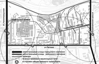
Figure 3. Analysis of transport and pedestrian accessibility of the territory
When analyzing the cadastral map, three categories of owners were identified: private property, municipal property and property of public legal entities. A relatively small percentage of the land is privately owned, while the rest of the territory, with the exception of the main passages, is leased by the municipality (Fig. 4). The average cost of land per square meter is 1010 rubles. Compared to the cost of land in the center, which is 1200 rubles, we can talk about its high value.
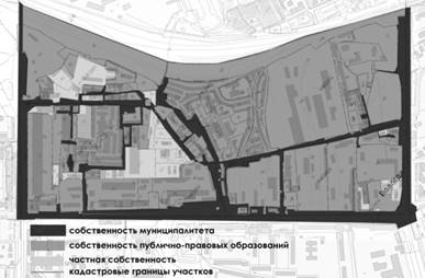
Figure 4. Analysis of territory owners within the red lines
The final stage of the analytical work was the study of land use rules for development of the city of Vologda. As a result of the analysis of the map, territorial zones were identified: 1) residential; 2) social and business; 3) production zone, engineering and transport infrastructure zone; 4) zone of special significance. The study of this layer led to the conclusion that the eastern half of the territory adjacent to the street. Leningradskaya can develop as a zone of public, business and commercial importance, with access to the natural watershed of the Zolotukha River, the landscaped coastline of which increases the investment attractiveness of this site. And the territory of the right bank of Zolotukha, which has significant transport and railway potential, can be regenerated on the basis of the production function (Fig. . 5).

Figure 5. Analysis of regulations and land use rules for development
Thus, the imposition of strata allows us to conclude that the study area has high urban development potential, requiring a territory regeneration project. The most acute conflict of interests arises in the western part of the site, where inefficient industry that does not bring high profits can be replaced by denser public, business and residential development. Renewal of the territory should occur in stages, starting with the restoration of cultural heritage sites and the revaluation of the communal and warehouse area. It is necessary to update the existing and provide future development with a new road transport network. New construction must be carried out with the parallel demolition of dilapidated buildings and structures for production, utility and storage purposes, with the transfer of the latter to a separate area (in the form of logistics centers and parking lots).
Bibliography:
- Anisimova L.V. Methodological principles of regeneration of the historical urban environment: textbook / L.V. Anisimova, L.Yu. Anisimov, E.N. Titorenko, V.Yu. Anisimov: ed. L.V. Anisimova; Min. and science of the Russian Federation; Vologda. state Univ.-Vologda: VoGU, 2017-97p.
- Rio Declaration on Environment and Development June 3-4, 1992 [Electronic resource] // UN: website. - Access mode: http://www.on.org/ru/documents/decl_conv/declarations/pdf/riodecl.pdf.
- "Hammer and Sickle. Competition results". Electronic resource – Access mode: https://archi.ru/russia/54655/serp-i-molot
- Regional standards for urban planning of the Vologda region. Electronic resource - http://nashdom.vologda-portal.ru/planning/documents/normativy_gradostroitelnogo_proektirovaniya.
- Public cadastral map of Vologda. Electronic resource-https://pkk5.rosreestr.ru/
Similar articles
-
Air and gases in the vagina
viewing Updated: When, at the most intimate moment, a woman leaves her vagina with a characteristic sound, a very awkward situation arises that destroys the romantic mood. If the relationship with your partner is not very close, it...
-
Janine analogues and prices Analogues by indication and method of use
Janine is a new generation hormonal contraceptive for systemic use. The action of the drug is aimed at inhibiting the secretion of gonadotropic pituitary hormones, inhibiting the maturation of follicles and suppressing ovulation....
-
Regulon: instructions for use Switching to Regulon from other hormonal drugs
Hello Svetlana. First, I want to answer the most important question about what to do if you did not start taking Regulon or any other oral contraceptive on the 1st day of your menstrual cycle. As you know, the first tablet should...
-
Birth control pills Janine Indications for use
Zhanine's chemical composition is a single-phase and low-dose drug. The medicine affects the ovulation process and suppresses it. The use of Janine changes the consistency of the cervical fluid and prevents the advancement...
-
Contraceptive ring NuvaRing: instructions, contraindications, price Nuvaring why do the analysis
NuvaRing: instructions for use and reviews NovaRing is a combined hormonal contraceptive for intravaginal use. Release form and composition Dosage form of NuvaRing - vaginal ring: transparent,...
-
When the husband is against the child, how to get pregnant without his knowledge?
Sometimes you can become pregnant due to negligence. To prevent this from happening, it is important to know how you can conceive a child by accident and what means you can use to avoid an unwanted pregnancy. Also in this article you can find information about...